It looks like my info on Not free OS mapping could be wrong. I have just read the article released by Grough Routes and you can read it HERE
Thanks to ebygomm's comment on my previous post, i started looking round the net to see what the latest was.
Tuesday, March 30, 2010
Monday, March 29, 2010
Rhinog Fach and Y Llethr photo's
I have now managed to load up the photo's from last weekends walk to Cwm Nantcol. So for everybody who was there and anybody else who might be interested, Here they are.
Saturday, March 27, 2010
Free OS mapping. Ha
I am led to believe that the "free" OS mapping that we are eagerly waiting for is not going to happen for us walkers.
The freebies are for companies that use 1:10,000 scale maps for the likes of house searches, boundary issues and road planning etc.
The maps we use ie 1:25,000 and 1:50,000 are not going to be included.
Isn't that just typical.
We will find out for sure on April 1st.
Has anybody heard anything different?
Thursday, March 25, 2010
New gear results
I tried some new gear out during our Wales weekend walk. I had 2 new pairs of boxer shorts. 1 pair of Icebreaker 200 boxers and 1 pair of Xbionic boxers.
The Icebreakers are Merino wool and the Xbionic are 90% polymide.
I wore the Icebreakers first and after a couple of hours i was getting some discomfort in the groin area. This did not improve all day.
At the end of the walk i was in some discomfort and when i got back to base i found that the seams had taken the skin off my groin and i was in a bit of pain. A hot shower and a liberal dose of dettol antiseptic cream and i hoped that it would improve enough for sundays walk.
On sunday i put the Xbionics on and found they were comfortable even on the problem area. After sundays tough walk, i was aware of the problem caused yesterday but it wasn't any worse and they felt very comfortable.
From now on the Icebreakers will be left in the drawer and i will be using xbionics.
Sheila and i both used the short ultralight event gaiter from integral designs these worked very well. It was great not to struggle with the full length gaiters and having no zips was a pleasure. I don't know about anybody else but when i wear long gaiters, i feel i need a sit down for 5 minutes to recover from the effort of putting them on.
Both of our new shell garments, my Cloudveil koven and Sheila's Berghaus paclite worked faultlessly. Considering the rain, combined with the humidity in the forestry, we were impressed with the performances.
Tuesday, March 23, 2010
Cwm Nantcol, Rhinog Fach and Y Llethr. Sun 21st Mar 2010
We had been looking forward to doing this walk but their had been some doubts whether it would happen given the lousy weather.
Sunday morning was glorious sunshine and not much cloud at all.
We drove into Cwm Nantcol and parked up at the end of the road at Maes-y-garnedd, a remote hill farm. The sign said £2 parking/ car which was paid at the farm house.

 The Flock. (less Teg who took the photo)
Setting off along a good track up Bwlch Drws-Ardudwy our spirits were high as the scenery on both sides of the valley is beautiful and somewhat rugged.
Behind us was the clear view of Moelfre.
In front our goal. Rhinog Fach.

The path undulates and gets very boggy in parts but is mainly in good condition. When the path crosses the 350 metre contour keep a sharp lookout on the right hand side for a vertical track up a very steep mountain side. This can easily be missed in poor conditions.
Even in good conditions it can be mistaken for a stream, but once across the wall and on the path it becomes obvious.

The photo doesn't do the path any justice, it is very steep. This photo was taken about 3/4 of the way up and is looking straight down into the valley.
Once the near vertical levels out, the route is clear and there is some gradually rising ground ahead for the legs to recover and stop shaking.
We decided to have a 10 minute break here.
 The route ahead was up the shoulder running NE/SE. This was a steady pull with no difficulties. We could feel the wind gathering momentum and one or two dark clouds were forming.
On reaching the 1st top, the northerly point, the wind was very fierce and you had to shout to be heard.
 Rhinog Fach summit from the northerly point of the ridge.
We made our way along the ridge where we came to a wall with the summit cairn above it. We stopped here just for a few minutes to take a photo and then we got off the top before we were blown off. I had to hold onto my cap or else it would have been down the valley.
 Rhinog Fach Summit cairn. With Moi adorning it! Ha.
Below the summit we found a sheltered spot and had lunch and then carefully made our way down to the col above Llyn Hywel. Great care has to be taken getting down here as it was a bit tricky with the wind and the rain. The slabs were very slippy.
 The descent from the peak to the col.
 View looking to the col with Llyn Hywel to the right and beyond is our next goal Y Llethr.
Again the track up to the skyline of Y Llethr is steep but not problamatic. The views across the valleys were becoming less and less as the cloud came in.
By the time we hit the snow which had accumulated against the wall at the top the visibility had deteriorated.
 The wall was our guide to the summit cairn (if thats what you can call it). We didn't hang around as it was too cold and windy to admire anything. On reaching the cairn we struck WNW on pathless terrain until we reached the wall.
We knew that from here the route was a bit hit and miss as there was no definate path back to the start point, but there was enough open country to plot our own route.

We headed for some old mine workings and a sheepfold which were marked on the map. The terrain was rough heather and rocks and not that pleasant to walk on.
We followed a wall down into the valley bottom and crossed a stream where it wasn't too deep.

From here we followed a wall heading north which joined up with our initial path and from here it was an easy stroll back to the cars. Just as the heavens absolutely poured down.
The walk had been tough, but very enjoyable. It's a terrific area, quite rugged hills. We only saw 2 other people all day and its a backpackers paradise with lots of good water about.
We set off around 10 o'clock and we got back to the car at 4.30pm. We stopped for about 30/40 mins in total for lunch and coffee and to rejuvenate the legs after some of the steep pulls.
There is much more that can be done in this area, we will return soon maybe.
(More pics to follow)
Sunday morning was glorious sunshine and not much cloud at all.
We drove into Cwm Nantcol and parked up at the end of the road at Maes-y-garnedd, a remote hill farm. The sign said £2 parking/ car which was paid at the farm house.


Setting off along a good track up Bwlch Drws-Ardudwy our spirits were high as the scenery on both sides of the valley is beautiful and somewhat rugged.
Behind us was the clear view of Moelfre.
In front our goal. Rhinog Fach.

The path undulates and gets very boggy in parts but is mainly in good condition. When the path crosses the 350 metre contour keep a sharp lookout on the right hand side for a vertical track up a very steep mountain side. This can easily be missed in poor conditions.
Even in good conditions it can be mistaken for a stream, but once across the wall and on the path it becomes obvious.

The photo doesn't do the path any justice, it is very steep. This photo was taken about 3/4 of the way up and is looking straight down into the valley.
Once the near vertical levels out, the route is clear and there is some gradually rising ground ahead for the legs to recover and stop shaking.
We decided to have a 10 minute break here.

On reaching the 1st top, the northerly point, the wind was very fierce and you had to shout to be heard.

We made our way along the ridge where we came to a wall with the summit cairn above it. We stopped here just for a few minutes to take a photo and then we got off the top before we were blown off. I had to hold onto my cap or else it would have been down the valley.

Below the summit we found a sheltered spot and had lunch and then carefully made our way down to the col above Llyn Hywel. Great care has to be taken getting down here as it was a bit tricky with the wind and the rain. The slabs were very slippy.


Again the track up to the skyline of Y Llethr is steep but not problamatic. The views across the valleys were becoming less and less as the cloud came in.
By the time we hit the snow which had accumulated against the wall at the top the visibility had deteriorated.

We knew that from here the route was a bit hit and miss as there was no definate path back to the start point, but there was enough open country to plot our own route.

We headed for some old mine workings and a sheepfold which were marked on the map. The terrain was rough heather and rocks and not that pleasant to walk on.
We followed a wall down into the valley bottom and crossed a stream where it wasn't too deep.

From here we followed a wall heading north which joined up with our initial path and from here it was an easy stroll back to the cars. Just as the heavens absolutely poured down.
The walk had been tough, but very enjoyable. It's a terrific area, quite rugged hills. We only saw 2 other people all day and its a backpackers paradise with lots of good water about.
We set off around 10 o'clock and we got back to the car at 4.30pm. We stopped for about 30/40 mins in total for lunch and coffee and to rejuvenate the legs after some of the steep pulls.
There is much more that can be done in this area, we will return soon maybe.
(More pics to follow)
Rhinog FWA 20th March 2010
Having checked Metcheck we decided to forsake Rhinog Fach until Sunday.
Today, Saturday, the mist was as predicted, low with quite heavy rain. Clearing late afternoon.
We drove to Llyn Tecwyn Isaf just off the A496 south of Harlech for a low level walk. Parking at SH 635 373.

The path led us south west up through the woods and then North to a small chapel at Llandecwyn. The views across Tremadog bay to Portmeirion are stunning.
There are many beautifully carved grave stones here and it's a credit to the local people.
 Carrying on along a good path we came to the dam at the reservoir Llyn Tecwyn Uchaf.
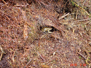
We followed the north shore and we couldn't help noticing the burnt hillside. Whether this was natural or just burning back we don't know.

Fortunately we spotted a survivor.


Today, Saturday, the mist was as predicted, low with quite heavy rain. Clearing late afternoon.
We drove to Llyn Tecwyn Isaf just off the A496 south of Harlech for a low level walk. Parking at SH 635 373.

The path led us south west up through the woods and then North to a small chapel at Llandecwyn. The views across Tremadog bay to Portmeirion are stunning.
There are many beautifully carved grave stones here and it's a credit to the local people.

We followed the north shore and we couldn't help noticing the burnt hillside. Whether this was natural or just burning back we don't know.

Fortunately we spotted a survivor.

At the end of the Llyn we entered the forestry and followed the track to Caen -y- Coed. On the way it was decided that sustenance was required and so a seating area was found in a soft part of the forestry.

From Caen-y-Coed we headed south and then south east to a farm called Llenyrch, from here we crossed a fence line and picked up the path at the side of a stream leading into Aron Prysor. As we reached the stream there was quite a large waterfall and with the amount of rain we had had during the night and morning it was in good spate.
The stream had to be crossed to follow the path up to the Llyn Trawsfynydd Dam. It was a little bit too deep for some of our flock who decided to try their luck further up and down stream. Some of us just waded through, wet feet and all and then had a good laugh at the others.

All safely across we followed the gorge up to the dam. Its a huge reservoir and we had a 10 minute break here to admire the surroundings.
The weather had picked up and it had stopped raining.
Some of the surrounding tops were clearing and it looked as though it would be a good onward walk.
From the dam we headed SW and picked up the trail at the side of a conduit, a small canal like structure taking water to the reservoir.
This continued for a mile until we reached the sump/sluice.

We crossed this with care as it was about 6ft deep and made our way north through farmland to pick up the minor road leading back to the start point.
This was a delightful walk, in an area we had never been to before.
As the day improved the scenery just got better and better. We had started off in foul weather gear and we could have been in shorts at the end.
We considered this route just as an FWA but it's worth expanding at some point in the future.

Some more photos can be seen HERE
Monday, March 22, 2010
Frustrating to say the least.
Tonight, instead of posting my trip to the Rhinogs as i should have done, i have been trying to get my head round Grough Routes. Having put the routes on the maps and filling in all the waypoints and points of interest i have lost it all. Am i annoyed! You bet.
Yes it's probably my fault, but i have not found it very user friendly. Well not to me anyway!
I have now given up until tomorrow before the screen goes through the square window..
I will hopefully post tomorrow on what turned out to be a fantastic trip. Brilliant area.
Yes it's probably my fault, but i have not found it very user friendly. Well not to me anyway!
I have now given up until tomorrow before the screen goes through the square window..
I will hopefully post tomorrow on what turned out to be a fantastic trip. Brilliant area.
Saturday, March 20, 2010
Lousy weather
Today saw the mizzy down low with poor visibility and fairly heavy rain. After looking at metcheck the forecast was poor until late afternoon.
The forecast for Sunday was decent.
An executive decision was made to do a FWA today and save Rhinog Fach until Sunday.
It was a good decision we have had a lovely days walk.
Not enough time at present to go through the route as Tea in the pub is calling.
Will post on Monday with both routes.
The forecast for Sunday was decent.
An executive decision was made to do a FWA today and save Rhinog Fach until Sunday.
It was a good decision we have had a lovely days walk.
Not enough time at present to go through the route as Tea in the pub is calling.
Will post on Monday with both routes.
Friday, March 19, 2010
Cwm Nantcol
We are in Cwm Nantcol at present and the weather is fairly clear. The tops are visible but you will have to wait for the pics as i have forgot to bring the cable. The tops around Blaenau are clouded over so the forecast that rain is on the way looks correct.
Hopefully tomorrow it will still be ok, as we plan to get up Rhinnog Fach and Liethr during the Cwm Nantcol walk.
More to follow.
Hopefully tomorrow it will still be ok, as we plan to get up Rhinnog Fach and Liethr during the Cwm Nantcol walk.
More to follow.
Monday, March 15, 2010
Gosforth Weekend
This weekend was our trip up to Sheila's mums, as we do every 2/3 weeks. It was also the inaugural trip for the new car.
After the highlights of a shopping trip to Whitehaven we went for a coffee to St Bees. We watched one chap, with fully laden rucksack, saying his farewells to what i presume were his parents as he sets off on his Coast to Coast adventure.
It brought back memories of the trip we did.
He did the usual wetting of the boots in the sea, and then with hugs all round he was off up the track to St Bees head. Hope it goes well for him.
The day was beautiful, with very clear visibility. I must say i have never seen the Isle of Man or the hills of Dumfries quite so sharp.
We decided to have a drive up to Wasdale head and take some photographs.
 This is the new motor with Wast water and Great Gable behind.

Sheila and Mum at Wasdale Head Hotel.
Some more pics can be viewed HERE if any one is interested.
After the highlights of a shopping trip to Whitehaven we went for a coffee to St Bees. We watched one chap, with fully laden rucksack, saying his farewells to what i presume were his parents as he sets off on his Coast to Coast adventure.
It brought back memories of the trip we did.
He did the usual wetting of the boots in the sea, and then with hugs all round he was off up the track to St Bees head. Hope it goes well for him.
The day was beautiful, with very clear visibility. I must say i have never seen the Isle of Man or the hills of Dumfries quite so sharp.
We decided to have a drive up to Wasdale head and take some photographs.


Sheila and Mum at Wasdale Head Hotel.
Some more pics can be viewed HERE if any one is interested.
Tuesday, March 9, 2010
More phone issues.
Below is a message i received from View Ranger digital mapping for mobiles support. As a number of people could be considering this option after the positive review in Feb TGO magazine i thought i would share the content. If you are not a techie like me, it might be helpful. (Thanks to View Ranger help guys)
You WILL need some sort of GPS (internal or external Bluetooth) for the phone to work with ViewRanger.
Phones with internal GPS (like the Nokia 5800) work perfectly fine. It could be argued as a Bluetooth GPS costs more (on top of the cost of the phone) it will be more accurate, and battery life on the phone would also last longer (as it is not powering the GPS). But you can buy a phone with internal GPS and still use a Bluetooth external GPS anyway.
Please see our documentation on Bluetooth GPS if you are considering buying one as there are things to watch out for.
http://shop.viewranger.com/article.php?category_id=120&article_id=60
Friday, March 5, 2010
The Phone.
Well after many weeks of deliberation the phone i chose was the Samsung Omnia HD. So i went into town to purchase the said item and guess what. NOBODY sold it! Absolutely none of the big providers contract it or sell it.
I will have to choose another. I'm sick as a parrot.
I will have to choose another. I'm sick as a parrot.
Tuesday, March 2, 2010
Stoves test.
This post is round 2 of the which stove/which fuel saga that i started in an earlier post.
The stoves i have used for my tests are made by me except for 1 which is a Hi Gear meths burner.
Let me first say that i have carried out these tests solely for my own benefit and not for any commercial use.
None of the tests were carried out under lab type conditions or serious scrutiny. I didn't record water or ambient temperatures, but just for the record the tests were carried out in the evenings and the temperature was probably just above freezing. (feb 2010)
Basically, if the kit works and it boils 0.5L of cold water straight from the tap, in a reasonable time and i can get my kit weight down then that's what i want to know. I'm not too concerned if one was 5 seconds faster than the other. etc etc

The stoves shown above are, from left to right :-
A unpressurised coke can. A unpressurised aluminium wine bottle, A pressurised Aluminium wine bottle and pan stand combined, The Hi Gear burner and the Esbit burner and pan stand.
The weights of the stoves are again left to right:- 8gr, 30gr, 40gr, 57gr, 10gr.
I also made 2 windshields. A Cone type and a plain round type.

The cone weight which also includes 2 tent pegs for pan support is 47gr. The round wind shield is 27 gr.
Fuel costs. 0.5L of Methylated spirit cost me £1.00.
1 box of Genuine Esbit tablets. 20 tabs x 4gr. each cost me £2.80.
In all the meths burners, i filled them with 50ML of fuel and tested each one in turn, boiling the 0.5L of cold water with the cone shield and then the round shield.
The pressurised burners needed about 5ml of extra fuel to pre warm the burner to get the jets working properly.
What surprised me was just how similar the burn times were for the home made burners.
Give or take 10/15 seconds each boiled the water in 6 minutes. Each burner then quickly ran out of fuel.
The Hi Gear burner boiled the water in 5.75 minutes and there was still fuel left which burned for another minute.
The round shield, using the same fuel load, just failed to boil the water prior to the fuel running out. Except for the Hi Gear burner which boiled in 6.75 minutes. So i am adding on another 5ML of fuel for the round wind shield.
With the Esbit tablets i upturned the meths burners and lit 2.0 tablets, then 3.0 tablets but the Esbits didn't boil the water until i put 4 tablets on and even then it was touch and go. It took just over 8 minutes to boil.
4.5 tabs is what i would use in the field.
The same results occurred for the burner and pot stand.
One thing that was very noticeable with the Esbit set up was the smell given off. With or without a windshield the smell was awful. I'm not sure i could stand this.
Also i tried Esbit copies and these proved quite difficult to light. The Esbits lit very easily in comparison.
So,
Meths burners.
0.5L meths weighs 455gr. (which includes the bottle).
With the cone shield i used 50ml, weight 45gr cost £0.10p
With the round shield i used 55ml, weight 50gr, cost £0.11p
From 0.5L bottle at best i can boil 10 lots of water.
Esbits,
1 box of Genuine Esbit tablets containing 20 x 4gr tablets weighs 80gr. The box is negligible.
The best i can achieved is 4.5 tablets per boil. weight 18gr, cost £0.63p
So to boil 10 lots of water with Esbits would weigh 180 gr and cost £6.30p
(If you took the equivalent weight in Esbits as Meths then you would be able to boil 25 lots of water for Esbits against 10 for meths.
Therefore, the weight is considerably less using Esbits rather than Methylated spirit on a like for like basis, but the cost is significantly more. And then there is the awful smell.
If i had to cook in the tent porch then Esbits would not be considered.
If i was able to cook away from the tent then Esbits are the way to go if the cost isn't too prohibitive.
But Esbits take around 30% longer to boil water than Methylated spirit.
Choices/Choices.
My Choice.
I am going to take the Cone windshield. Weight 47gr.
I am going to take the unpressurised coke can burner. Weight 8gr. (no warming up fuel needed)
I am going to use a combination of fuels i will take 0.5L Methylated spirit. and 2 box's of Esbits. Weight 160 gr.
In total thats enough fuel for 19 lots of water. ( If you take 7 minutes as an average boil time then 7mins X 19 =133 mins of cooking in total.
How long will that last?
Well that depends on too many variables to put in this post. Anybody interested can work that out themselves.
Total kit weight. 670 gr. divided between 2 of us is 335gr. each and the weight will reduce after every meal/brew etc.

The stoves i have used for my tests are made by me except for 1 which is a Hi Gear meths burner.
Let me first say that i have carried out these tests solely for my own benefit and not for any commercial use.
None of the tests were carried out under lab type conditions or serious scrutiny. I didn't record water or ambient temperatures, but just for the record the tests were carried out in the evenings and the temperature was probably just above freezing. (feb 2010)
Basically, if the kit works and it boils 0.5L of cold water straight from the tap, in a reasonable time and i can get my kit weight down then that's what i want to know. I'm not too concerned if one was 5 seconds faster than the other. etc etc

The stoves shown above are, from left to right :-
A unpressurised coke can. A unpressurised aluminium wine bottle, A pressurised Aluminium wine bottle and pan stand combined, The Hi Gear burner and the Esbit burner and pan stand.
The weights of the stoves are again left to right:- 8gr, 30gr, 40gr, 57gr, 10gr.
I also made 2 windshields. A Cone type and a plain round type.

Fuel costs. 0.5L of Methylated spirit cost me £1.00.
1 box of Genuine Esbit tablets. 20 tabs x 4gr. each cost me £2.80.
In all the meths burners, i filled them with 50ML of fuel and tested each one in turn, boiling the 0.5L of cold water with the cone shield and then the round shield.
The pressurised burners needed about 5ml of extra fuel to pre warm the burner to get the jets working properly.
What surprised me was just how similar the burn times were for the home made burners.
Give or take 10/15 seconds each boiled the water in 6 minutes. Each burner then quickly ran out of fuel.
The Hi Gear burner boiled the water in 5.75 minutes and there was still fuel left which burned for another minute.
The round shield, using the same fuel load, just failed to boil the water prior to the fuel running out. Except for the Hi Gear burner which boiled in 6.75 minutes. So i am adding on another 5ML of fuel for the round wind shield.
With the Esbit tablets i upturned the meths burners and lit 2.0 tablets, then 3.0 tablets but the Esbits didn't boil the water until i put 4 tablets on and even then it was touch and go. It took just over 8 minutes to boil.
4.5 tabs is what i would use in the field.
The same results occurred for the burner and pot stand.
One thing that was very noticeable with the Esbit set up was the smell given off. With or without a windshield the smell was awful. I'm not sure i could stand this.
Also i tried Esbit copies and these proved quite difficult to light. The Esbits lit very easily in comparison.
So,
Meths burners.
0.5L meths weighs 455gr. (which includes the bottle).
With the cone shield i used 50ml, weight 45gr cost £0.10p
With the round shield i used 55ml, weight 50gr, cost £0.11p
From 0.5L bottle at best i can boil 10 lots of water.
Esbits,
1 box of Genuine Esbit tablets containing 20 x 4gr tablets weighs 80gr. The box is negligible.
The best i can achieved is 4.5 tablets per boil. weight 18gr, cost £0.63p
So to boil 10 lots of water with Esbits would weigh 180 gr and cost £6.30p
(If you took the equivalent weight in Esbits as Meths then you would be able to boil 25 lots of water for Esbits against 10 for meths.
Therefore, the weight is considerably less using Esbits rather than Methylated spirit on a like for like basis, but the cost is significantly more. And then there is the awful smell.
If i had to cook in the tent porch then Esbits would not be considered.
If i was able to cook away from the tent then Esbits are the way to go if the cost isn't too prohibitive.
But Esbits take around 30% longer to boil water than Methylated spirit.
Choices/Choices.
My Choice.
I am going to take the Cone windshield. Weight 47gr.
I am going to take the unpressurised coke can burner. Weight 8gr. (no warming up fuel needed)
I am going to use a combination of fuels i will take 0.5L Methylated spirit. and 2 box's of Esbits. Weight 160 gr.
In total thats enough fuel for 19 lots of water. ( If you take 7 minutes as an average boil time then 7mins X 19 =133 mins of cooking in total.
How long will that last?
Well that depends on too many variables to put in this post. Anybody interested can work that out themselves.
Total kit weight. 670 gr. divided between 2 of us is 335gr. each and the weight will reduce after every meal/brew etc.

Monday, March 1, 2010
Good Weekend
Back now from our survival birthday weekend.
After a very bleak start driving over Corney fell in a complete blizzard the weekend weather decided not to follow the dire forecast predicted. Saturday was supposed to be poor visibility, it was as bright as a button with fabulous views.
Anybody who ventured up onto the tops on saturday would have had a great time.
We decided to stay low level due to the hangovers and then go for a late lunch. We picked a walk along the river in Eskdale and then up to Stanley Force waterfall.
We tried to get over the stepping stones on the way back to the bar at Boot house, but i am afraid we were just too wobbly.
Thankfully i managed to hold the camera steady for a few scenic photo's during the weekend.


Subscribe to:
Posts (Atom)